Savannah is one of the most visited cities in the US state of Georgia. Its history dates to February 12, 1733, when General James Oglethorpe arrived in the area with settlers aboard the ship Anne. They disembarked at Yamacraw Bluff in present-day central Savannah, and here they founded both the city and the colony of Georgia. After its founding, Savannah was developed according to the so-called Oglethorpe town plan, with a special division into the city’s neighborhoods.
In 1751, Georgia became a British crown colony with Savannah as its capital. During the American War of Independence, the British held their positions in the city from 1778 to 1782, but Savannah became American and through the 19th century it developed into an important port city that was also among the largest in the southern states. In the year 1800, it had reached 5,000 inhabitants, and that number increased tenfold over the course of the century.

Columbia is the capital and one of the largest cities in the US state of South Carolina. The town’s history dates to European settlers who founded a fort and trading post on the west bank of the Congaree River, and in 1754 a ferry service was established across the river to settlers to the east. With natural falls in the river, mills and manufacturing grew, and in 1786 the city was chosen as the new capital of South Carolina and was named Columbia after a vote in the Senate.
Canals were dug as transport routes, which were eventually replaced by the railway. Columbia had just over 1,000 inhabitants in the early 1800s, and it increased grew to over 9,000 in the 1860s, when the city was destroyed in 1865 during the American Civil War. The city was rebuilt after the war, and development became evident in the following decades with e.g. a tram network the streets. Textile factories provided growth in the city, where high-rise buildings were built downtown throughout the 20th century.
 Charleston, South Carolina[/caption]
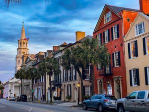
Overview of Charleston
Charleston is the largest city in the US state of South Carolina. The town was founded in 1670 with the name Charles Town in honor of King Charles II. It happened west of the Ashley River and thereby northwest of the present center, to which Charles Town was moved in 1680. The new town quickly grew into being one of the largest cities in North America. The city was fortified at the beginning of the 18th century, and many African slaves came to and through the city during this time. The plantations made Charles Town prosperous, and 11,000 lived here in 1770.
South Carolina declared independence in 1774, but British forces overcame American troops in 1780, and the British held the city until 1782. After that came great growth, which, among other things, was due to Eli Whitney’s invention of a cotton gin, which made cotton the primary export throughout the 1800s. In 1860, South Carolina seceded from the United States as the first of the country’s southern states, and on April 12, 1861, the first battle of the American Civil War took place when coastal batteries fired on Fort Sumter at the entrance to Charleston harbor. After the war, the city was rebuilt, which was repeated after a devastating earthquake in 1886.
Today, you can enjoy some lovely walks in Charleston’s so-called Historic District, which covers the old part of Charleston on the peninsula between Ashley River and Cooper River. In the neighborhood you can see many houses from the 1700s and 1800s, and right in the center at the intersection of Broad Street and East Bay Street is the Old Exchange and Provost Dungeon building. The building was constructed 1767-1771 and has over time housed several functions such as the stock exchange and customs authorities.
About the Charleston travel guide
Contents: Tours in the city + tours in the surrounding area
Published: Released soon
Author: Stig Albeck
Publisher: Vamados.com
Language: English
About the travel guide
The Charleston travel guide gives you an overview of the sights and activities of the American city. Read about top sights and other sights, and get a tour guide with tour suggestions and detailed descriptions of all the city’s most important churches, monuments, mansions, museums, etc.
Charleston is waiting for you, and at vamados.com you can also find cheap flights and great deals on hotels for your trip. You just select your travel dates and then you get flight and accommodation suggestions in and around the city.
Read more about Charleston and the United States
United States Travel Guide: https://vamados.com/usa
City tourism: https://visitcharle-ston.com
Main Page: https://www.vamados.com/
Buy the travel guide
Click the “Add to Cart” button to purchase the travel guide. After that you will come to the payment, where you enter the purchase and payment information. Upon payment of the travel guide, you will immediately receive a receipt with a link to download your purchase. You can download the travel guide immediately or use the download link in the email later.
Use the travel guide
When you buy the travel guide to Charleston you get the book online so you can have it on your phone, tablet or computer – and of course you can choose to print it. Use the maps and tour suggestions and you will have a good and content-rich journey.