


Flagstaff is a city in the northern part of Arizona. It is in an area originally inhabited by the Sinagua people, who lived there from around 500 to 1425 CE. The modern settlement of Flagstaff began in 1876 when a group of settlers from Boston camped near a small spring and raised a flagstaff to celebrate the nation’s centennial. The arrival of the Atlantic and Pacific Railroad in 1882 transformed Flagstaff into a busy railroad town, and settlers established shops, saloons, and more.
The city’s growth continued with the establishment of the lumber and ranching industries, which played a significant role in its early economy. Flagstaff’s strategic location along historic Route 66 and its proximity to natural wonders like the Grand Canyon have since then made it a popular destination for tourists. The city’s elevation provides a cool climate and stunning views of the surrounding San Francisco Peaks.

Las Vegas is the capital of Nevada og it is world famous for its many sparkling neon signs, impressive shows and fantastic hotel and casino complexes. Here are activities 24 hours a day; whether you go here to gamble, to get married in one of the many Wedding Chapels or just to soak up the pulse and entertainment of the city.
The entertainment at the hotels is centered around the main street of Las Vegas Boulevard, also called The Strip. A lot of mega hotels are located along the street, and part of the visit here in Nevada’s largest city is to visit them and their extravagant buffets and special attractions, such as volcanic eruptions, large waterfalls, fountains, pirates and the half-size Eiffel Tower.

Zion National Park is an American national park located in a mountainous area in southwestern Utah. It is a place where the Colorado Plateau meets the Mojavo Desert and the Great Basin drainage basin and desert. That meeting creates a rich animal and plant life and many geological formations such as buttes, mesas and canyons between the national park’s mountains.
The large southern section around the town of Springdale was made a national park in 1919, while the northwestern section around Kolob Canyon was added in 1937. The main attraction in the park is the canyon that the Virgin River has carved out of the plateau over millions of years.
Read more about Zion National Park
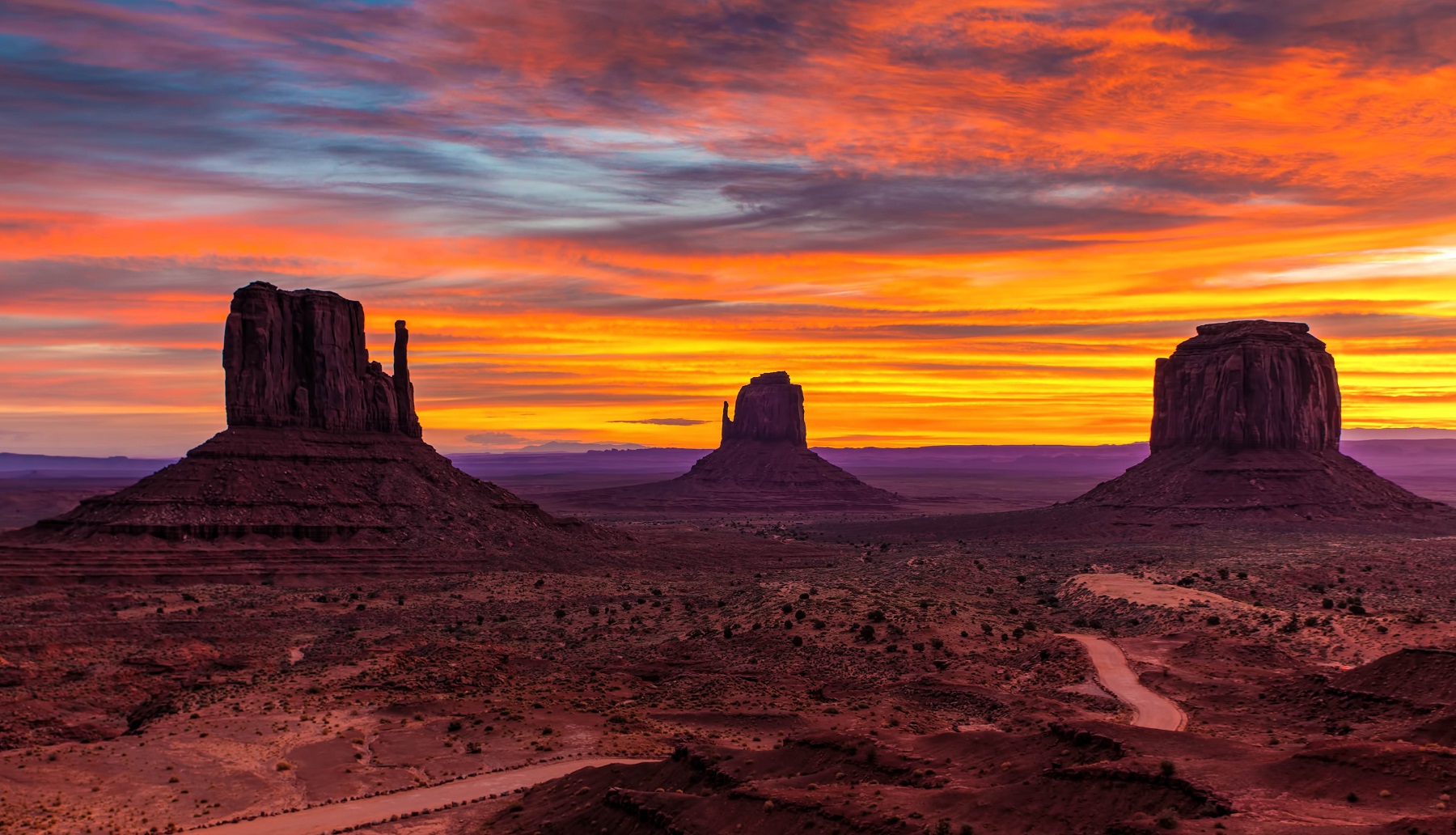
Monument Valley is an area of Arizona’s desert landscape that is famous for its many rock formations that stand scattered and rise from the otherwise flat land. Many will nod in recognition to Monument Valley because they have seen one or more American western movies, but the distinctive formations are, with or without western films, one of the most iconic landscapes in the western United States.
Monument Valley is centrally located on the so-called Colorado Plateau, which spreads over an area of 337,000 km2 around the Colorado River and some of its tributaries. The plateau form parts of the states of Arizona, Utah, New Mexico and Colorado, and it is known for several well-visited sights such as the Grand Canyon and Monument Valley.
Read more about Monument Valley

Phoenix is the capital and largest city of the US state of Arizona. The area was cultivated in bygone times by the Hohokam people, and the remains of their civilization could be seen in the 1800s, when settlers began to arrive at today’s Arizona. In 1867 Jack Swilling came here and he started cultivating the land.
More settlers arrived, and Lord Darrell Duppa suggested calling the growing place Phoenix, like a city built on a defunct civilization. The new town was formally approved in 1868, when a post office was opened with Jack Swilling as postmaster. In 1870, the inhabitants chose to move the city approximately 5 km to the west, and Phoenix grew to around 2,500 inhabitants in 1880.
 Grand Canyon National Park
Overview of Grand Canyon National Park
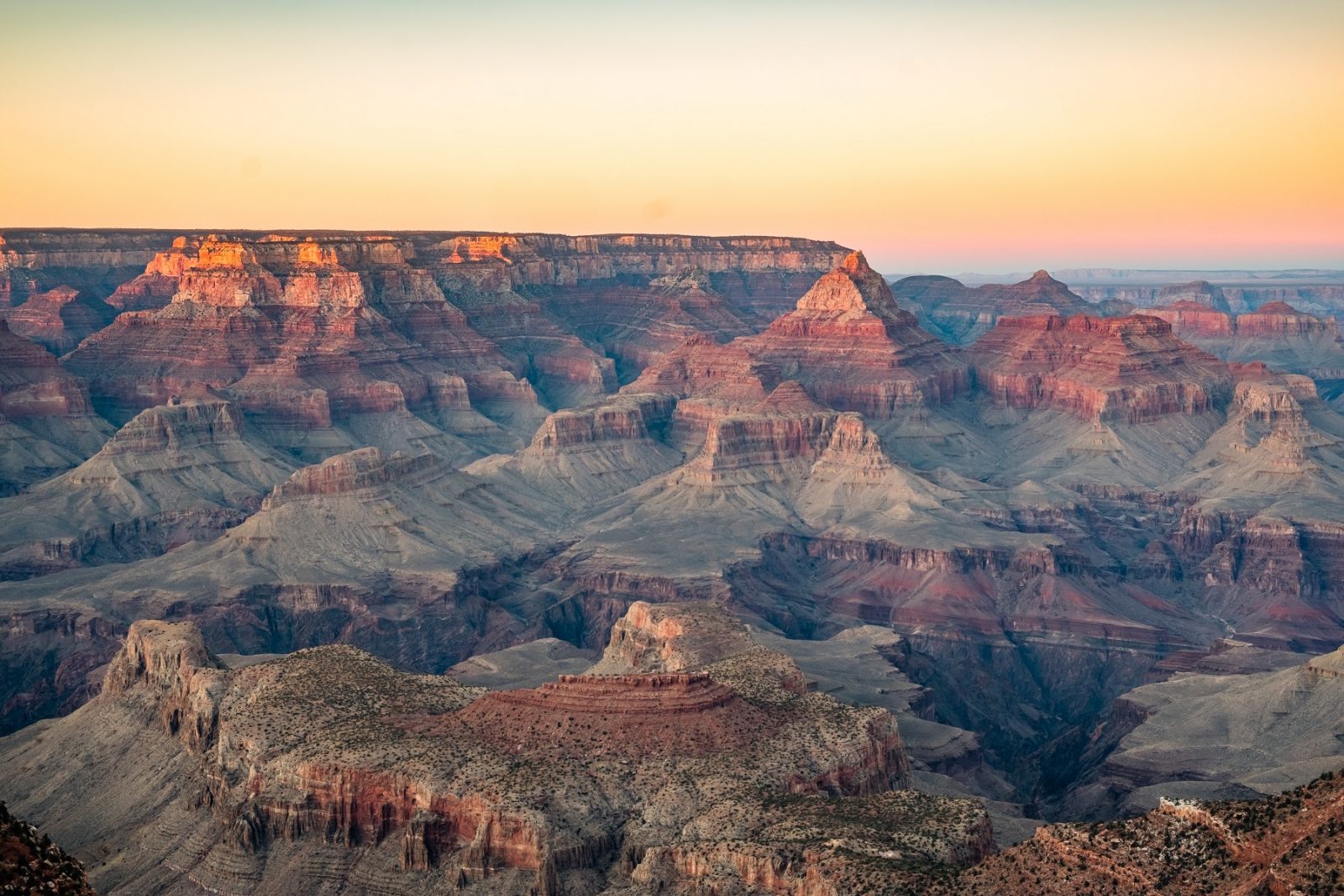
Grand Canyon National Park is an large park that is home to the world-famous natural wonder of the Grand Canyon. The park is located around 447 kilometers of the Colorado River, which over millions of years has shaped the landscape into the colossal canyon that today is in the northeastern part of the state of Arizona.
The dimensions of the Grand Canyon are huge, and the gorge is between 6 and 29 kilometers wide. The depth varies with the greatest depth reaching up to 1,600 meters, and the meandering course of the Colorado River continues to dig deeper, although it happens at a geological pace. All the way along the river, the canyon is bursting with an artist’s sense of shapes and colors, and everywhere there is a play in the sun’s rays against the mainly red-hued rock formations, and that is an unforgettable sight.
About the Jasper travel guide
Contents: Tours in the city + tours in the surrounding area
Published: Released soon
Author: Stig Albeck
Publisher: Vamados.com
Language: English
About the travel guide
The Jasper travel guide gives you an overview of the sights and activities of the Canadian city. Read about top sights and other sights, and get a tour guide with tour suggestions and detailed descriptions of all the city’s most important churches, monuments, mansions, museums, etc.
Jasper is waiting for you, and at vamados.com you can also find cheap flights and great deals on hotels for your trip. You just select your travel dates and then you get flight and accommodation suggestions in and around the city.
Read more about Victoria and Canada
Canada Travel Guide: https://vamados.com/canada
City tourism: https://visitvic-toria.ca
Main Page: https://www.vamados.com/
Buy the travel guide
Click the “Add to Cart” button to purchase the travel guide. After that you will come to the payment, where you enter the purchase and payment information. Upon payment of the travel guide, you will immediately receive a receipt with a link to download your purchase. You can download the travel guide immediately or use the download link in the email later.
Use the travel guide
When you buy the travel guide to Victoria you get the book online so you can have it on your phone, tablet or computer – and of course you can choose to print it. Use the maps and tour suggestions and you will have a good and content-rich journey.