Quick search
CTRL+K
Quick search
CTRL+K

Tirana is the capital of Albania and for decades, it was one of Europe’s most closed and inaccessible cities for tourists. Today it is almost the other way around when you think of exploring the sights and neighborhoods and in the meeting with the friendly people of Albania.
Tirana is a city created through centuries of diverse construction from a variety of rulers and the culture and style of leaders. The 13th century Justinian Fort once formed the center of the city, which has since been influenced by not least the Ottoman Empire, Italy and the special Albanian communism.
In the interwar period in the 20th century, Albania was in many ways like an Italian state, although it was a country with its own rule and king. Italian architectures and urban planning largely influenced Tirana’s development and laid the grounds for the capital’s boulevards and squares.
In 1944, Albanian communists led by Enver Hoxha took over power after a freedom struggle against occupation troops from Italy and then Germany. It became the starting point in a historically unique period with decades of relative isolation from the outside world. There are many remains in Tirana from this time; this is, for example, Mother Albania and Enver Hoxha’s pyramid.
In the very heart of Tirana, you can see Skanderbeg Square, which since the 1990s has been subject to rapid development with new construction and beautiful architecture that is also seen in many other places in the city and in the surrounding area, where the mountains is an great place to go for an excursion.
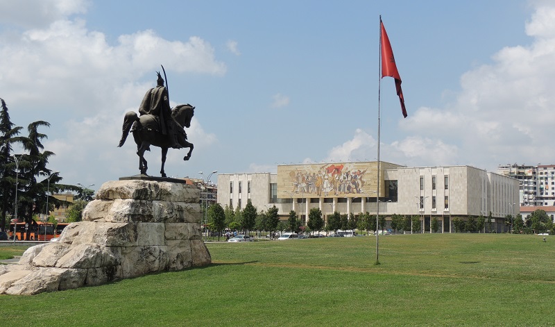
Sheshi Skënderbej is the central square in Tirana and thus the most important in the whole country. In Albania’s time before communism, there were different buildings here than today. This applied, for example, to Tirana’s Orthodox cathedral, old bazaar, town hall and a central fountain. These were blown up during communism to make way for the constructions of that time in a new urban planning.
In the middle of the square and in front of a large green area stands an equestrian statue of the Albanian national hero George Skanderbeg/Gjergj Skënderbeu, who lived in the years 1405-1468. Skanderbeg became the leader of the Albanian people, and he managed to keep the expanding Ottoman Empire at bay before it annexed Albania after his death. In the same place as the Skanderbeg monument, there used to be a statue of the Soviet leader Josef Stalin.
There was also a statue of Albania’s communist leader Enver Hoxha in the square. It used to grace the site between the National History Museum and the National Bank of Albania, but in connection with the fall of communism, the Hoxha statue also fell.
Today, the square is dominated by buildings from the communist era. The Palace of Culture is located where the city’s bazaar used to be, the Tirana International Hotel replaced the city’s Orthodox cathedral, and the National History Museum is located where Tirana’s City Hall used to be.
The National History Museum is among Albania’s most important. It opened in 1981 in the center of Tirana, and the architect Enver Faja was behind the large museum building. On the outside of the museum, a large mosaic dominates the front above the entrance. The mosaic symbolizes the Albanian people.
The museum contains different themes and periods in Albania’s culture and history. For example, you can experience antiquity, the Middle Ages, the Second World War and the communist era as periods, and there is also a general review of Albanian culture with a focus on iconography, among other things.
Of recent history, the exhibition on the Albanian resistance during World War II and the following communist era can be recommended. Here you get interesting information and historical accounts of what belonged to Europe’s very closed states.
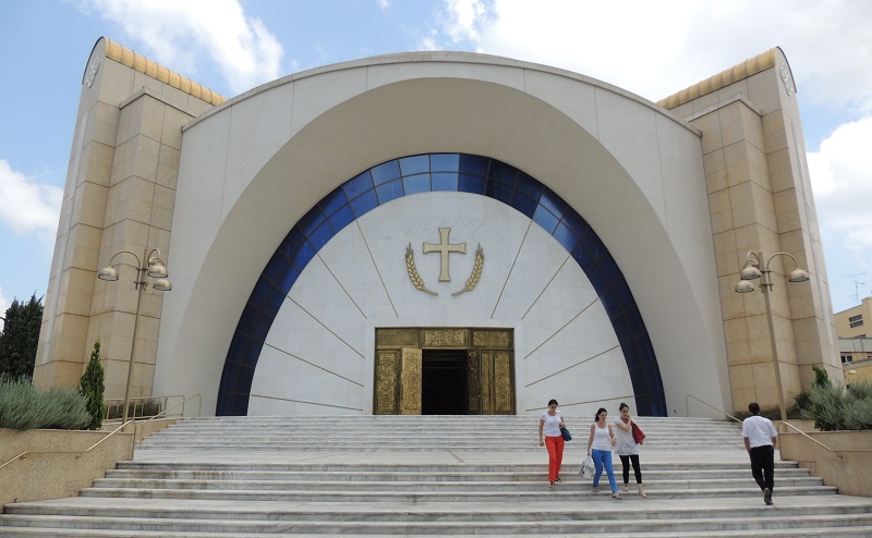
Cathedral of the Resurrection of Christ is the cathedral of the Albanian Orthodox Church in Tirana and at the same time one of the more characteristic recent buildings in the city. The church was built as a large domed building with a free-standing bell tower reaching for the sky, and it is centrally located in the Albanian capital.
The building was opened on 24 June 2012 after eight years of construction and inaugurated in 2014. The opening marked the 20th anniversary of the restoration of the Albanian Orthodox Church after the communist decades. The cathedral replaced the former main church in Tirana, which until demolition in the 1950s was located where the city’s palace of culture is located today.
The church complex contains the cathedral itself, the 46 meter high bell tower, the holy synod, a library, a small museum, etc. The architectural and engineering firms Steven P. Papadatos and Lizardos Engineering Associates designed the cathedral, while Archbishop Anastasios was behind the bell tower, which symbolizes the four evangelists.
Blloku is a neighborhood known as a neighborhood for the wealthy and formerly for the rulers of the Albanian Communist Party. Before the communists built new housing for the elite, there were a number of factories here, but that quickly changed with, among other things, the residence of the head of state Enver Hoxha, which can still be seen on the corner of the streets Rruga Ibrahim Rugova and Rruga Ismail Qemali.
Blloku was closed off to the general population during the communist era. Since the communist era, much new has been built in the neighborhood, where large apartment complexes have sprung up for the new economic elite in the city and the country. There are also a number of shops and restaurants here.
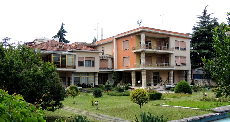
Enver Hoxha’s House was the residence in the formerly closed quarter, Blloku, that the head of state Enver Hoxha lived in. Hoxha was Albanian head of state in the years 1944-1985. As head of state, he was the first secretary of the Labor Party in the country, and he also headed the national army and the country’s military.
Enver Hoxha’s rule was communist and developed not least from the 1970s in a different direction than Lenin’s Soviet Union and Mao’s China. Thus Hoxha and Albania stuck to an anti-revisionist version of Marxist-Leninist communism.
Hoxha was born in Gjirokastër in southern Albania, and his political life began in earnest with his refusal to join the fascist party of the occupying Italians in 1939. In the same year, he opened the store Flora in Tirana, but this was later closed by the authorities as rallying point for the opposition. In the following years, Hoxha worked his way up from a role in the First Provisional Central Committee of the Communist Party to become the country’s undisputed leader.
Tirana Mosaic, locally called Mozaiku i Tiranës, is an archaeological museum located on the site where in 1972 the remains of a church built in the 4th-5th centuries were found. Through archaeological excavations, the remains of a Roman house from the 200s were also uncovered, and the preserved mosaics form the core of the museum.
Today, you can thus see and experience the finely preserved mosaics, which feature geometric patterns and representations of fish and poultry. The mosaics are believed to have been laid in the basement of the historic Roman villa. On the spot you can also see the found ruins of the old church as well as various archaeological finds that have been made here.
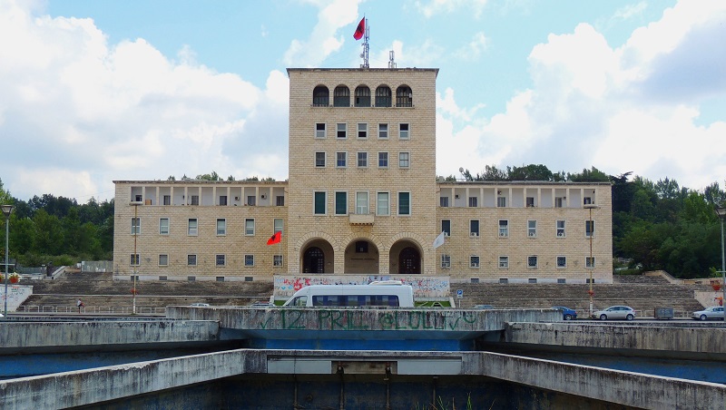
The University of Tirana is Albania’s leading university, whose foundation dates back to 1957, when it was established as Tirana State University/Universiteti Shtetëror i Tiranës. This happened by merging five existing educational institutions. From the death of head of state Enver Hoxha in 1985, the university’s name was named after him until the fall of communism.
One of the five educational institutions in 1957 was the Polytechnic University of Tirana, which itself was and is one of the city’s and country’s leading educational institutions. It was founded in 1951, making it Albania’s oldest university. More than 10,000 students study here various subject areas within technical and natural science fields, thus supplementing the other faculties at the university.
The main building, which is the seat of the rectorate, is a noble work of rationalism. It was designed by the Italian Vittorio Ballio Morpurgo and is located as a fixed point at the southern end of the splendid boulevard Bulevardi Deshmorët e Kombit.
Bulevardi Dëshmorët e Kombit was laid out by Italian architects as Tirana’s splendid street. Initially, it was the architect Armando Brasini who designed the city’s main street in 1925, and he was a well-known urban planner and designer of the period-typical fascist architecture that originated in Italy.
The street was originally named after King Zog of Albania, but after the Italian invasion of Albania in 1939, it was renamed Viale del Impero. During this time, the boulevard was also changed compared to the original design.
During the country’s communist rule, Bulevardi Dëshmorët e Kombit continued to form the main street from north to south in the Albanian capital, and here there were, among other things, parades on communist anniversaries.
The boulevard is still pompously laid out, and there are many significant buildings, institutions and sights along it. This applies, for example, to the presidential palace, Piramida and Tirana’s architecturally characteristic university building, which is located as a fixed southern point.
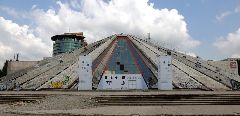
Piramida is one of the most distinctive buildings in Tirana. The futuristically designed structure was built as a museum for the country’s communist state leader Enver Hoxha, and it opened as the Enver Hoxha Museum/Muzeu Enver Hoxha in 1988.
Designed by Hoxha’s daughter and son-in-law, it was a monument to Hoxha’s Albania, which he had ruled from 1944 until his death in 1985. The pyramid was constructed of steel and glass and covered in marble. A red star originally adorned the top.
The museum closed with communism in 1991, and Piramida was set up as an international cultural center the same year. There have been various plans for the Piramida, which at one point was planned as a new opera house. The country’s new parliament building is also intended for this prominent place in the cityscape, but there are considerations to preserve the Piramida for historical-architectural reasons.
The Palace of Culture, locally known as Pallati i Kultures, was built at the request of the Communist Albanian Workers’ Party. The foundation stone was laid by the then leader of the Soviet Union, Nikita Khrushchev, in 1959, and the building was completed in 1963. The architecture is typical of the communist countries of Eastern Europe.
Various cultural institutions are located in the building. You can thus find the National Library of Albania/Biblioteka Kombëtare e Shqipërisë and the National Opera & Ballet Theatre/Teatri Kombetar i Operas dhe i Baletit here.
The National Library was established in 1920 and opened in 1922. The Opera & Ballet Theater was founded in 1953 and was initially located in the building of the Art Academy/University in Arteve, before the Palace of Culture was inaugurated. Here you can continuously see fine setups.
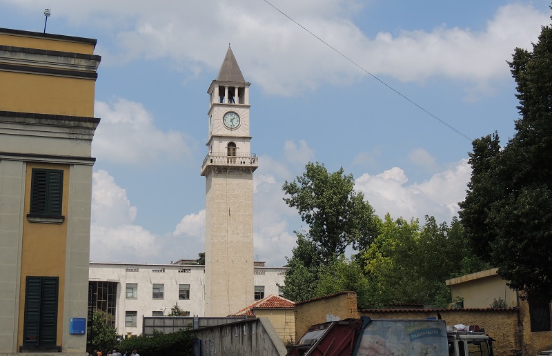
Tirana Clock Tower rises in the middle of Tirana’s streetscape, and at the time of its construction in 1822, with its 35 meters, it was the tallest building in the city. Haxhi Et’hem Bey was behind the construction, and he has also designed other works in the Albanian capital, such as the mosque next to the clock tower.
Upon completion, a Venetian clock was installed in the tower. It was replaced by a German clock in 1928, but as this was destroyed during WWII bombings, a clock from a church in the city of Shkodër was replaced in 1946. The current clock is Chinese and dates from 1970.
In the tower there is a staircase, and there is access to the top, from where you can look out over the city centre. On the way up, you can take a closer look at the internal construction, and from the top there are, among other things, a panoramic view of the central square of the capital; Sheshi Skënderbej.
Justinian’s Fort is a structure believed to date back to early Byzantine times around the 5th century, when it formed the center of the city. It was at this place that the main roads east-west and north-south met. The fort is named after Emperor Justinian, who ruled 527-565, but it is also known simply as Tirana Fort/Kalaja e Tiranës.
Not much of the fort has been preserved, but you can see part of the surrounding wall; however, this is from the Ottoman era and therefore somewhat newer than the original fort construction. In Murat Toptani street you can also see some of the foundations from the fort’s walls.
Originally the fort had a size of around 160×200 metres. At the end of the 18th century, a modern facility was built on the ruins of the old fort, and the noble family Toptani occupied the fort. During a siege of 5 months in 1817, it was partially destroyed, but subsequently rebuilt. This facility stood until 1832, when the Ottomans demolished the fort.
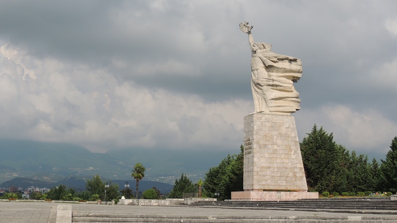
Mother Albania is a 12-meter high statue that was inaugurated in 1971 as a figurative symbol of the motherland, watching over those who gave their lives fighting for Albania. The statue stands in the Martyrs’ Cemetery/Varrezat e Dëshmorëve të Kombit.
This is the cemetery where those who fell in battles during the Second World War were buried, and thus it stands as a national monument to the battles. In addition to the fallen partisans, the communist state leader Enver Hoxha was also buried here after his death in 1985, but after the fall of communism, his grave was moved to a more humble location in a public cemetery in Tirana.
The statue of Mother Albania was made of concrete and was designed by artists Kristaq Rama, Muntaz Dhrami and Shaban Hadërri. It is set up on a pedestal where you can read the words “Lavdi e përjetshme hëlërëve të atdheut”, which means “Eternal era to the martyrs of the fatherland”.
Garvernes Bro, locally called Ura e Tabakëve, dates from the 18th century, when it was built as part of the road Rruga e Shëngjergjit. It was a road that led from Tirana to the city of Debar and the highlands east of Tirana.
Rruga e Shëngjergjit was important as many supplies of agricultural goods came to Tirana by this route and the name of the bridge came in response to the fact that many butchers and tanners lived in this very area. It suited the many goods that came this way.
Garvernes Bro crosses the stream Lanë, and its infrastructural importance lasted until the 1930s, when a new road gave access to the strategically important agricultural areas to the east. Since then, the bridge was allowed to fall into disrepair. This condition lasted until the 1990s, when the major restoration was carried out, and today it stands beautifully in the streetscape.
Parku Kombëtar Mali i Dajtit is a national park located around Mount Dajti, which rises to a height of 1,613 meters in the area east of Tirana. In addition to Dajti, the mountains Priska, Tujani and Brari are also part of the same mountain massif, and there are also rivers, gorges and other beautiful nature in the park.
The national park is a favorite excursion destination both in summer and winter. The fastest access is by road, which leads to fantastic viewpoints and other experiences, places to eat and so on, and along the way the Albanian capital is at your feet. However, the most beautiful access to the mountain is with the Dajti Ekspres cable car, which you can take from the outskirts of Tirana.
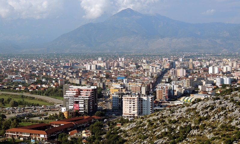
Shkodër is one of the largest and oldest cities in Albania. Its foundation is not known with certainty, but it was established by Illyrians from the Greek area. A time from the middle of the 200s BC. the city had the status of the capital of an Illyrian kingdom for the Ardiaei tribe. Since then there were several rulers over the city and the area, which came under the Ottoman Empire in the 1470s. For the Ottomans, Shkodër was a strategically important city on the roads to other parts of the Balkans and to the sea.
Today, Shkodër is an interesting city to visit, where you can experience the atmosphere of one of the country’s large provincial cities. The city’s modern center is Sheshi Demokracia square, where there are fountains and green spaces. At the square you can also see the Teatri Migjeni, which is Shkoder’s leading theatre. You can also take a walk along the elegant pedestrian street Rruga Kolë Idromeno, where there are shops, cafes and restaurants, and the cozy side street Rruga Gjuhadol.

Durrës is the second largest city in Albania and is located like Tirana’s port city on the Albanian Adriatic coast. The city’s early history started with the arrival of Greek settlers from Corinth and Korkyra in the 6th century BC. At that time the city was called Epidamnos, and it was also known as Dyrrachium. Dürres became part of the Roman Empire and later also the Byzantine Empire.
In the Middle Ages, both Bulgarians and Venetians fought over Durrës and the well-located area. In 1501, the Ottomans captured the city and their rule was maintained until 1912, before the Albanians gained their independence and freedom. Durrës briefly became the capital of the Principality of Albania, which soon became part of Italy. During World War II, Durrës was occupied by German troops, and after the war, the city became part of communist Albania.
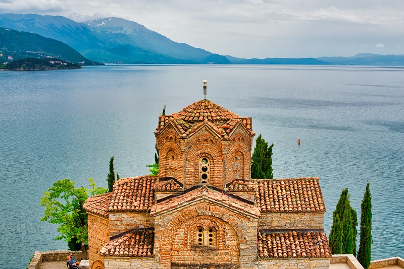
Lake Ohrid is a natural gem in the region between North Macedonia and Albania, and the city of Ohrid is the largest city around the lake. Its historical beginnings started with Greek settlers who gradually established the city of Lychnidos/Λύχνιδος. From the 5th century, slaves immigrated to the area, which they gradually took over.
The first time the name Ohrid, which is Slavic in origin, was mentioned in the year 879. Later, Ohrid was, among other things, the Bulgarian capital, before the Macedonian city grew and developed with its good location on various trade routes.
Today, Ohrid is a beautiful and interesting city on Lake Ohrid, located on the border between North Macedonia and Albania. Among the things you can see are some of the former 365 churches and chapels that were located in the city. There was one for every day, and that was one reason for the nickname as the Jerusalem of the Balkans.
However, Lake Ohrid, Ohridsko Jezero/Охридско Езеро, is the city and the region’s big draw. It is one of Europe’s oldest and deepest lakes and is home to around 200 endemic species. The lake is also on UNESCO’s list of world natural heritage.
Lake Ohrid is up to 288 meters deep and its area is 358 km². A good two-thirds of it is in North Macedonia. The lake and nearby Lake Prespas were formed geotectonically about five million years ago on the western side of the Dinaric Alps. Corresponding lakes were geologically normally filled up by sediments and thus disappeared as lakes. Lake Ohrid’s depth and low influx of sediments are attributed to the reason for its survival.
With regard to the geology and the presence of the many endemic species, the lake can be compared to, for example, Lake Baikal in Russia. With snowy mountains as a backdrop, clear water and fantastic panoramic views from, among other things, monasteries, a trip to Lake Ohrid is a scenic and unforgettable experience.
Tirana-Durres Highway
cityparkalbania.com
Rruga Papa Gjon Pali II
coin.al
European Trade Center
galeria-etc.com
Tirana-Durres Highway
qtu.al
Tirana-Elbasan Road
teg.al
Rruga Myslym Shyri, Rruga e Kavajës, Bulevardi Zogu I
Muzeu Historik Kombëtar
Sheshi Carpentry
Muzeu in Shkencave Të Natyrës
Rruga Kavajës
fshn.edu.al
Teleferiku Dajti Express
dajtiekspres.com
Kopshti Zoology
Rruga Haxhi Brari
The region around Tirana is considered to be one of the earliest inhabited areas of present-day Albania, thereby taking the settlements many thousands of years back. Traces of Illyrians have been found through archaeological discoveries, and in central Tirana the remains of a Roman house have been discovered.
Remains and buildings have also been found from the following centuries in the Roman times. Not least some parts of the castle that Emperor Justinian built in 520. The castle was excavated and restored in the 18th century by Ahmed Pasha Toptani. In the area and around Justinian’s castle, over the centuries, more houses were added and the number inhabitants increased.
In the 1400s, the Turkish Ottomans came to the Albanian area, and in connection with their first land and property registration in 1431-1432, several settlements were registered in and around present-day Tirana. At that time there were 2,028 houses and about 7,300 inhabitants here.
The scattered buildings lay on the trade routes in the area, but they only became a formal town in 1614, when Sulejman Bargjini founded Tirana in the form of an Ottoman town with mosque, hammam and a market area. Around those facilities, Tirana grew nicely through the 1600s-1700s.
The Ottoman Empire’s retreat from the Balkans was the result of both a weakened empire and a continued desire for freedom among the many people of the Balkan peninsula. The same was the case for the Albanians, who among the visible changes implemented that from 1889 onward Albanian was taught in the country’s schools.
The Albanian flag waved for the first time over Tirana in 1912, with Albania gained its independence. The Balkan wars of the following years destabilized the area and in a transition Tirana was temporarily conquered by the Serbian army.
At the Lushnjë Congress in 1920, Tirana was chosen as the interim capital of independent Albania, and great plans for the city’s development were initiated. The first sketches had been drawn in 1917, but an actual city plan first came about in 1923 from the ideas of Austrian architects.
Architects Florestano Di Fausto and Armando Brasini, who successfully worked in Benito Mussolini’s Italy, designed a new center for Tirana; This included the construction of ministerial buildings and the city’s boulevards and squares. From December 31, 1925, Tirana gained the status of permanent capital of the country.
Several different groups of people also set out for Albania in the 1920s, where there were changing political regimes. In June 1924, a political upheaval took place in the form of Fan Noli’s takeover of power. Fan Noli had founded the Albanian Orthodox Church, and he headed the country’s pro-British party. His liberal supporters won over former Prime Minister Zogu, who was forced into exile.
However, Zogu returned and he was elected president in 1925. In 1928, the monarchy was introduced, and Zogu became King Zog I. The monarchy lasted until 1939 with Zog as king, during which time the major facilities in Tirana continued with designs by Italian architects. Designs of the Royal Palace, the National Bank and other large buildings, among others.
In 1939, Albanian fascists came to power through a form of union with Italy, which ruled through a local puppet government. In Tirana, their rule became manifest; for example, larger streets and squares were named after famous facists.
Officially, Albania was a kingdom where Italian Vittorio Emanuele III was king. Despite almost being an Italian protectorate since 1926, Albania was invaded by Italian troops in April 1939. The Italian occupation lasted until the country’s capitulation in 1943, after which Albania was occupied by German troops.
In the years of occupation, the Albanian Communist Party was established, and here Enver Hoxha became the leading figure. Tirana was the center of the Communists’ activities, and they continually increased their connection to the activities against the German occupying forces.
On November 17, 1944, Tirana was liberated after fierce fighting between communists and German troops, and subsequently a communist regime was established in the country.
With the communists in power, Tirana was rebuilt and changed throughout the era lasting from 1944 to 1991. Some of the prestigious buildings in the center of the Italian era were demolished to make way for major construction in relation to communist ideology; among other things, the catholic cathedral was destroyed in favor of the Soviet-inspired cultural palace.
A statue of Soviet leader Josef Stalin was erected in a prominent square in the city, and a central boulevard got his name. Tirana was also changed traffic wise, prohibiting private motoring. Instead, bicycles and buses were the forms of transport, and it characterized the capital’s streets.
As part of the later isolation policy, Albania was industrialized, as was Tirana, where several factories were set up to secure production.
Expanded came to the center of Tirana, where a government district with residences for the country’s tops was erected. The Blloku neighborhood was an exclusive area where the population had no access. The dwelling of Enver Hoxha was also located in Blloku. Head of state Enver Hoxha died in 1985, and a visible memorial was erected in form of a pyramid built for his memorial.
In the 1990s, communist rule had fallen in favor of a rapid introduction of market economy. It created a new Albania and a new Tirana, which over time was greatly expanded. This time it was not standard housing as in previous decades, but rather elegant new houses, office buildings and other things that the new economy gave way to. Time was one with many and rapid changes, so some illegal construction was also created.
In recent years, many projects have been completed in Tirana, partly to beautify the city and partly to bring a stop to illegal construction. Thereby, today a harmonious and exciting city center awaits visitors.
 Tirana, Albania[/caption]
Overview of Tirana
Tirana is the capital of Albania and for decades, it was one of Europe’s most closed and inaccessible cities for tourists. Today it is almost the other way around when you think of exploring the sights and neighborhoods and in the meeting with the friendly people of Albania.
Tirana is a city created through centuries of diverse construction from a variety of rulers and the culture and style of leaders. The 13th century Justinian Fort once formed the center of the city, which has since been influenced by not least the Ottoman Empire, Italy and the special Albanian communism.
In the interwar period in the 20th century, Albania was in many ways like an Italian state, although it was a country with its own rule and king. Italian architectures and urban planning largely influenced Tirana’s development and laid the grounds for the capital’s boulevards and squares.
About the Whitehorse travel guide
Contents: Tours in the city + tours in the surrounding area
Published: Released soon
Author: Stig Albeck
Publisher: Vamados.com
Language: English
About the travel guide
The Whitehorse travel guide gives you an overview of the sights and activities of the Canadian city. Read about top sights and other sights, and get a tour guide with tour suggestions and detailed descriptions of all the city’s most important churches, monuments, mansions, museums, etc.
Whitehorse is waiting for you, and at vamados.com you can also find cheap flights and great deals on hotels for your trip. You just select your travel dates and then you get flight and accommodation suggestions in and around the city.
Read more about Whitehorse and Canada
Canada Travel Guide: https://vamados.com/canada
City tourism: https://visitwhite-horse.ca
Main Page: https://www.vamados.com/
Buy the travel guide
Click the “Add to Cart” button to purchase the travel guide. After that you will come to the payment, where you enter the purchase and payment information. Upon payment of the travel guide, you will immediately receive a receipt with a link to download your purchase. You can download the travel guide immediately or use the download link in the email later.
Use the travel guide
When you buy the travel guide to Whitehorse you get the book online so you can have it on your phone, tablet or computer – and of course you can choose to print it. Use the maps and tour suggestions and you will have a good and content-rich journey.


The University of Tirana is Albania’s leading university, whose foundation dates back to 1957, when it was established as Tirana State University/Universiteti Shtetëror i Tiranës. This happened by merging five existing educational institutions. From the death of head of state Enver Hoxha in 1985, the university’s name was named after him until the fall of communism.
One of the five educational institutions in 1957 was the Polytechnic University of Tirana, which itself was and is one of the city’s and country’s leading educational institutions. It was founded in 1951, making it Albania’s oldest university. More than 10,000 students study here various subject areas within technical and natural science fields, thus supplementing the other faculties at the university.
The main building, which is the seat of the rectorate, is a noble work of rationalism. It was designed by the Italian Vittorio Ballio Morpurgo and is located as a fixed point at the southern end of the splendid boulevard Bulevardi Deshmorët e Kombit.
Bulevardi Dëshmorët e Kombit was laid out by Italian architects as Tirana’s splendid street. Initially, it was the architect Armando Brasini who designed the city’s main street in 1925, and he was a well-known urban planner and designer of the period-typical fascist architecture that originated in Italy.
The street was originally named after King Zog of Albania, but after the Italian invasion of Albania in 1939, it was renamed Viale del Impero. During this time, the boulevard was also changed compared to the original design.
During the country’s communist rule, Bulevardi Dëshmorët e Kombit continued to form the main street from north to south in the Albanian capital, and here there were, among other things, parades on communist anniversaries.
The boulevard is still pompously laid out, and there are many significant buildings, institutions and sights along it. This applies, for example, to the presidential palace, Piramida and Tirana’s architecturally characteristic university building, which is located as a fixed southern point.

Piramida is one of the most distinctive buildings in Tirana. The futuristically designed structure was built as a museum for the country’s communist state leader Enver Hoxha, and it opened as the Enver Hoxha Museum/Muzeu Enver Hoxha in 1988.
Designed by Hoxha’s daughter and son-in-law, it was a monument to Hoxha’s Albania, which he had ruled from 1944 until his death in 1985. The pyramid was constructed of steel and glass and covered in marble. A red star originally adorned the top.
The museum closed with communism in 1991, and Piramida was set up as an international cultural center the same year. There have been various plans for the Piramida, which at one point was planned as a new opera house. The country’s new parliament building is also intended for this prominent place in the cityscape, but there are considerations to preserve the Piramida for historical-architectural reasons.
The Palace of Culture, locally known as Pallati i Kultures, was built at the request of the Communist Albanian Workers’ Party. The foundation stone was laid by the then leader of the Soviet Union, Nikita Khrushchev, in 1959, and the building was completed in 1963. The architecture is typical of the communist countries of Eastern Europe.
Various cultural institutions are located in the building. You can thus find the National Library of Albania/Biblioteka Kombëtare e Shqipërisë and the National Opera & Ballet Theatre/Teatri Kombetar i Operas dhe i Baletit here.
The National Library was established in 1920 and opened in 1922. The Opera & Ballet Theater was founded in 1953 and was initially located in the building of the Art Academy/University in Arteve, before the Palace of Culture was inaugurated. Here you can continuously see fine setups.

Tirana Clock Tower rises in the middle of Tirana’s streetscape, and at the time of its construction in 1822, with its 35 meters, it was the tallest building in the city. Haxhi Et’hem Bey was behind the construction, and he has also designed other works in the Albanian capital, such as the mosque next to the clock tower.
Upon completion, a Venetian clock was installed in the tower. It was replaced by a German clock in 1928, but as this was destroyed during WWII bombings, a clock from a church in the city of Shkodër was replaced in 1946. The current clock is Chinese and dates from 1970.
In the tower there is a staircase, and there is access to the top, from where you can look out over the city centre. On the way up, you can take a closer look at the internal construction, and from the top there are, among other things, a panoramic view of the central square of the capital; Sheshi Skënderbej.
Justinian’s Fort is a structure believed to date back to early Byzantine times around the 5th century, when it formed the center of the city. It was at this place that the main roads east-west and north-south met. The fort is named after Emperor Justinian, who ruled 527-565, but it is also known simply as Tirana Fort/Kalaja e Tiranës.
Not much of the fort has been preserved, but you can see part of the surrounding wall; however, this is from the Ottoman era and therefore somewhat newer than the original fort construction. In Murat Toptani street you can also see some of the foundations from the fort’s walls.
Originally the fort had a size of around 160×200 metres. At the end of the 18th century, a modern facility was built on the ruins of the old fort, and the noble family Toptani occupied the fort. During a siege of 5 months in 1817, it was partially destroyed, but subsequently rebuilt. This facility stood until 1832, when the Ottomans demolished the fort.

Mother Albania is a 12-meter high statue that was inaugurated in 1971 as a figurative symbol of the motherland, watching over those who gave their lives fighting for Albania. The statue stands in the Martyrs’ Cemetery/Varrezat e Dëshmorëve të Kombit.
This is the cemetery where those who fell in battles during the Second World War were buried, and thus it stands as a national monument to the battles. In addition to the fallen partisans, the communist state leader Enver Hoxha was also buried here after his death in 1985, but after the fall of communism, his grave was moved to a more humble location in a public cemetery in Tirana.
The statue of Mother Albania was made of concrete and was designed by artists Kristaq Rama, Muntaz Dhrami and Shaban Hadërri. It is set up on a pedestal where you can read the words “Lavdi e përjetshme hëlërëve të atdheut”, which means “Eternal era to the martyrs of the fatherland”.
Garvernes Bro, locally called Ura e Tabakëve, dates from the 18th century, when it was built as part of the road Rruga e Shëngjergjit. It was a road that led from Tirana to the city of Debar and the highlands east of Tirana.
Rruga e Shëngjergjit was important as many supplies of agricultural goods came to Tirana by this route and the name of the bridge came in response to the fact that many butchers and tanners lived in this very area. It suited the many goods that came this way.
Garvernes Bro crosses the stream Lanë, and its infrastructural importance lasted until the 1930s, when a new road gave access to the strategically important agricultural areas to the east. Since then, the bridge was allowed to fall into disrepair. This condition lasted until the 1990s, when the major restoration was carried out, and today it stands beautifully in the streetscape.
Similar to Tirana Travel Guide
