
Longyearbyen in the Arctic archipelago of Svalbard is one of the northernmost cities of the world, and in a both harsh and lovely climate, people have been attracted to the islands the recent centuries for hunting, whaling, coalmining, research and the magnificent scenery. All of this is something you can experience while visiting the northernly places with a few town and great nature.
Norwegian Longyearbyen and Russian Barentsburg are the two largest urban communities in Svalbard. They are located at a distance that often makes tourists visit both places during a stay on the islands. The sea route between the towns is an journey through the vast nature and with a look to both historical mining communities and glaciers.
Longyearbyen, like so many other places in Svalbard, started out as a mining town, but today it has much else to offer tourists. Shops, restaurants, a museum and many excursions are available. For many, Longyearbyen also serves as the site for the main stay in Svalbard, although there is also a hotel in Barentsburg.
A special time is in the summer when the sun shines around the clock for several months, and the midnight sun is an impressive experience. Equally impressive is the Northern Lights that prevail in the dark, long winter. In that way, Svalbard has several seasons and has something to offer anyone looking for a secluded destination with special sights and activities.
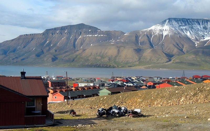
With approximately 2,000 inhabitants, Longyearbyen is the largest settlement on Svalbard, and the city functions as the administrative and commercial center of the archipelago. Politically, Svalbard is administered by Norway, and the highest representative of the Norwegian government is the Governor, who must ensure that Norway’s rights and obligations in connection with the Svalbard Treaty from 1920 are respected.
Longyearbyen is named after the American John Munroe Longyear, who with the company Arctic Coal Company established the town as a mining community in 1906. The town was then called Longyear City, and it was bought by Store Norske Spitsbergen Kulkompagni in 1916. Ten years later it got its current name.
The German Kriegsmarine destroyed most of the city during World War II, after which it has been rebuilt and continuously expanded. Today, tourism, research and administration dominate rather than the previously dominant mining.
The Svalbard Museum is an interdisciplinary museum where you can experience Svalbard’s culture, history, nature and the research that takes place on and around the archipelago.
Through storytelling and effects in the architecturally fine museum building, you come back to the Dutch rediscovery of Svalbard in the 16th century and follow the development to today’s society with mining, tourism and polar research.
You also get an insight into Svalbard’s nature on land and at sea here. The climate is polar, but there is vegetation on the islands, and not least a large biological production takes place in the sea. Of the animal life on land, the polar bear is the most well-known, and in addition to it, there are three other species of mammal; Svalbard reindeer, arctic fox and eastern field mouse. The last one came to Svalbard on board Soviet ships with crew and supplies for Grumant in the middle of the 20th century.
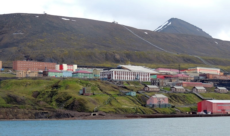
The town of Barentsburg is the second largest town on Svalbard. It was established by the Russian Coalfields Green Harbor in 1916 and sold to the Dutch in the 1920s and named after Dutchman Willem Barents, who rediscovered the Svalbard archipelago in 1596.
The town was sold to the Soviet Union in 1932, which with the company Arctic Coal/Arktikugol/Арктикуголь founded a major mining community. Despite Norwegian supremacy over Svalbard, co-signatories of the Svalbard Treaty from 1920 can operate mines on the archipelago, and Russia is now taking advantage of this with Barentsburg.
In 1943, the city was almost completely destroyed when the German battleship Tirpitz bombarded it beyond recognition. The later reconstruction started in 1946, and the architecture is very different from what you see in Longyearbyen, for example. The style is Soviet with imposing buildings adapted to life and operations in the Arctic.
435 people lived in Barentsburg in 2011, and coal is still mined and sold on various markets. Supplies and labor come from Russia and Ukraine, and in addition to mining, a source of income is the tourists who come here from Longyearbyen.
When you get to the port of Barentsburg, the town is at the top of a series of stairs. At the top, you can enjoy the view over Barentsburg’s harbor and over the Grønfjord from a viewing platform. This is also where the city center starts. In front of the rise from the stairs, a large square opens up, and Barentsburg’s main street runs across it, which is also the town’s main street.
In the center of the city, as in so many other places in the historical Soviet Union, you can see a statue of the communist leader Lenin. The statue is the second northernmost in the world; only one in the Pyramiden on Svalbard stands closer to the North Pole.
In Barentsburg there are various buildings that you can take a look at. One of the newer and more modern buildings is the Russian Consulate, which is the world’s northernmost diplomatic mission.
The town’s school is centrally located on the main street, and it is elegantly painted with motifs from partly the marine environment and partly cathedrals in Norway as well as in its native Russia. The decoration was created by art students from Saint Petersburg.
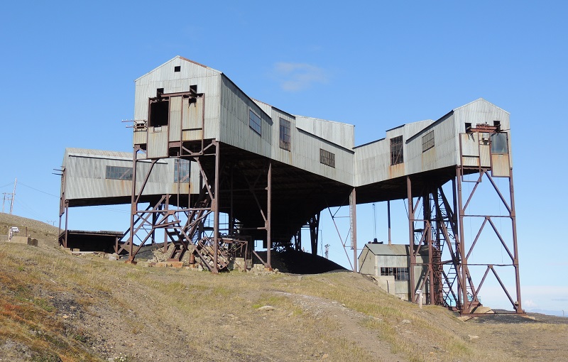
The cable car station is one of the most distinctive and characteristic buildings in Longyearbyen, and its profile can be seen from most of the city.
During its operation, the central functioned as a collection point for the coal that came from various mines around the city. In three directions, you can still see the wooden racks that connected the central station to the individual mines in a row, and in the direction of the port, where the coal was shipped, you can see a piece of the preserved cableway with the metal containers where the coal was transported in .
At this fine museum you can experience the exciting and dramatic expeditions that set out with airships from Svalbard towards the North Pole. These are the ships America 1906-1909, Norway in 1926 and Italia in 1928.
Models, documents, images and effects tell the stories that also involved fatal editorial actions; among others, Norwegian Roald Amundsen perished during such an attempt.
The museum is detailed in the review of the events of the Arctic exploration, and here you can get a good knowledge of the many challenges the expeditions faced. You can also watch longer films from trips such as Norway’s journey from Svalbard to Alaska.
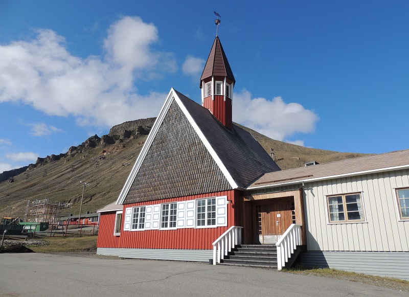
After just 50 days of construction, Svalbard Church was completed on 28 August 1921. In 1943, Longyearbyen was bombarded by German ships, and in that event the church, which was rebuilt from the foundation stone in 1956 to the inauguration on 14 August 1958, burned down. The church’s altarpiece, baptismal font and silver baptismal font are all from the first church and had been stored in Britain during the war.
Svalbard Church was built and functions as a church for all residents of the archipelago, and thus people from e.g. Barentsburg and Sveagruva are also always welcome here.
The University Centre in Svalbard is a public university that was founded in 1993 by the Norwegian state. The idea of the university was and is to offer higher education in arctic natural science.
There are around 350 students at the English-language university, and they come from many parts of the world; the majority, however, from Norway.
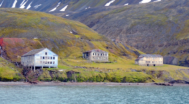
Grumant is the name of a former Soviet settlement that began its history around 1910. It was later operated by the company Arctic Coal/Arktikugol/Арктикуголь, which was also active in Barentsburg and Pyramiden.
Grumant once had approximately 1,200 inhabitants and was thus a larger mining community. However, it was closed in 1961 due to declining production and difficult shipping conditions. The coal had to be driven along a track with a 40 centimeter gauge to Coles Bay southwest of Grumant.
Today, you can see the abandoned buildings that stand along the coastline between Longyearbyen and Barentsburg, where many tourists sail during the summer season. The buildings are the remains of many more, which were demolished and removed by Arktikugol according to now former Norwegian rules.
You can see that there have been many coal mines around Longyearbyen on the hillsides around the town. The cable car center and the cable cars are also a witness to the intense mining of the coal that fueled the city in the past.
Today, the primary mining takes place in Sveagruve south of Longyearbyen and in Russian Barentsburg to the southwest. However, you can see the last mine in operation around Longyearbyen in the area east of the city.
The drive there is in itself an experience with large wetlands and a flat land between the mountains and, in season, rich in birds and plants. It already gives an impression of Svalbard’s magnificent nature after the exit from Longyearbyen, and the coal mine stands as an active industrial reminder of the much greater activity in the area in the past.
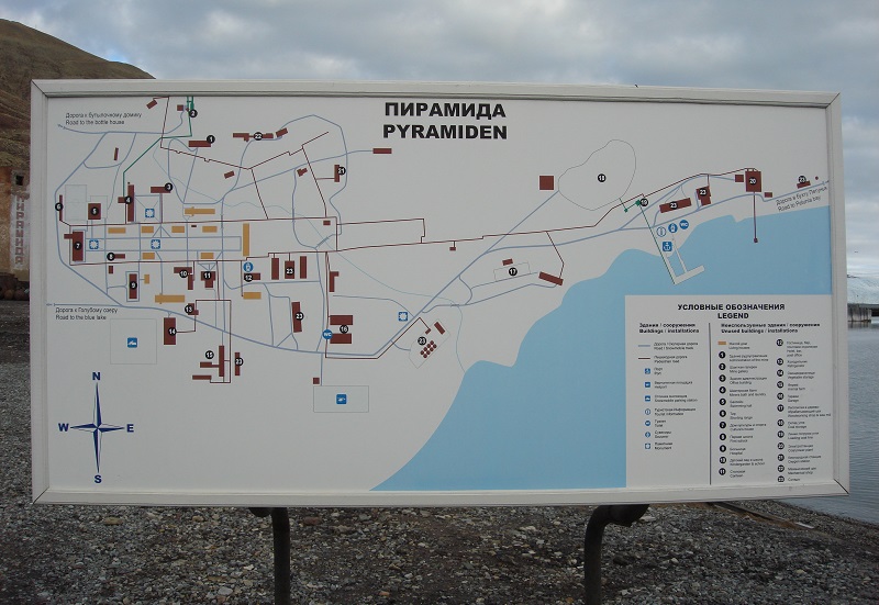
Pyramida is a former Russian mining community that the company Arctic Coal/Arktikugol/Арктикуголь founded and operated in the same way as the current Barentsburg west of Longyearbyen.
The history of the pyramid started with the founding of Sweden in 1910. It named it after the pyramid-shaped mountain located here. The city was sold to the Soviet Union in 1927, and after the fall of the union, Russia operated the community until it closed in 1998.
Around 1,000 people once lived and worked in the Pyramid, whose history through the buildings will stand for centuries in the Arctic climate, where decomposition occurs extremely slowly compared to other places on the globe.
Arktikugol still owns the Pyramid, which they have partially restored since 2007. These include the Tulip Hotel and a generator station that makes it possible for tourists to spend the night here.
The Pyramid’s city sign is one of the landmarks in the city, whose name is here written in Russian and Swedish. By it is a pyramid in metal bars with a cross on top. At the foot of it you can see a coal wagon with the last ton of coal that was mined from the town.
In the city’s central square, you can see the world’s most northerly statue of Lenin, and around it are public buildings, residences and places of activity like a cultural center. Up the mountains behind the Pyramid, you can see the facilities that brought coal from the city’s mines to the Pyramid’s port, where it was shipped.
During the Pyramid’s active time, there was a football team, swimming club, jazz band and, in general, an active existence among the miners with families who were here on two-year contracts before returning to the Soviet Union. Around the Pyramid, there are also areas with a microclimate that, under favorable conditions, allows modest agriculture, which was also exploited.
Hovedgaten
svalbardbutikken.no
Elvesletta
Main street
Spitsbergen Airship Museum
spitsbergenairshipmuseum.com
Svalbard Museum
svalbardmuseum.no
Henningsen Transport & Guiding
Sjøskrenten
htg.svalbard.no
Svalbard is believed to have been discovered by Scandinavians in the 1100s, and they called the archipelago Svalbarð, which means cold coasts. The name may also refer to parts of Greenland and the island of Jan Mayen, as the land was then considered to be continuous. The Scandinavians used Svalbard for hunting and fishing for some time.
Holland was one of the rich European powers of the 16th century, which through trade had created both solid revenues and an internationally oriented society. In 1596, the country introduced a reward to those who could find the Northeast passage north of Russia to Asia, and the Amsterdam City Council equipped two ships to conduct the experiment.
In mid-May 1596 Willem Barentz set out from the Dutch coasts. On June 10, the expedition came to the Bjørne Island, and on June 17 they gained land acquaintance with Spitsbergen, which they thereby rediscovered after centuries without human activity on the archipelago. Barentz and crews sailed around several fjords before sailing to the Bear Island in late June and on to the northeast, where Willem Barentz died on June 20, 1597, after surviving the winter on Novaja Zemlja.
The first hunting expeditions in the seas around Svalbard went to the Bear Island, to which the English Muscovy Company organized a trip in 1604. The target was a large colony of walruses which were locally eradicated after the following years.
From 1611, it was the whales around Spitsbergen that attracted interested fishing companies. The majority of English and Dutch whalers were present, but there were, for example, Spanish and French boats in the area. The Muscovy Company believed they had exclusive rights to the catches, and they sent armed boats to remove competitors.
The English aggression caused the Netherlands to declare the English right to void and the sea free, while the King of Denmark-Christian, Christian IV, regarded the area as belonging to his kingdom due to the geographical connection with not least the possession of Greenland. Thus, in 1615, Denmark-Norway sent tax collectors to foreign boats, which however paid off.
In 1614, England and the Netherlands had effectively divided Spitsbergen and the sea area between them, and the Dutch created the company Noordsche Companie for this purpose. After a few years, the English Muscovy Company got into financial difficulties, making the Netherlands dominant in the catchment areas. They settled on base in northwest Svalbard and allowed only a limited Danish presence. England was directed to the south, and French to the north coast and the open waters.
Formally, Denmark-Norway had not abandoned the claim for Svalbard, but the area nonetheless transitioned to a status of terra nullius; a country under no sovereignty.
The Dutch base was Smeerenburg on the island of Amsterdam Island. It was home to about 200 employees. The total activities in and around Svalbard were increased through the 1600s to a total of about 10,000 people and up to 300 ships.
Gradually, whaling moved from land to sea. Instead of the fjords, it became the open sea and the pelagic zone that, with the development of technology, became an increasingly important part of the activities, and with it many of the settlements disappeared.
The whaling lasted into the 18th century, when the Dutch continually downsized the activities to completely abandon the whaling around the archipelago in 1770. The English moved their fishing boats to other areas in the early part of the following century.
During the same time, hunting other than the whaling took place. To a lesser extent, polar bears, seals and polar foxes were hunted.
The geographical exploration of Svalbard started in earnest around 1610, when the developing whaling sought new areas.
In the middle of the century, it was found that Spitsbergen was an island and that Svalbard was not associated with Greenland, as would otherwise be assumed.
It was the coastlines and the sea area that were the focus of the expeditions, and thus the interior of the islands remained unknown for many years.
Scientific expeditions were started by Russia on a 1764-1766 voyage, and this type of exploration was followed by, among others, Norway, France, England and Sweden over the years. Among the well-known expeditions are the Swedes Adolf Erik Nordenskiöld and Otto Torell’s two tours in the 1860s.
Svalbard has many times in history been the starting point for exploration trips to the North Pole. With the location close to the top of the Earth, the northwest of Spitsbergen has been the basis for some of these journeys.
Several attempts to reach the North Pole itself were tried from the end of the 19th century. This happened, among other things, in hot air balloons and in airships, of which the ship Norway with Roald Amundsen as expedition leader succeeded with his presence in 1926. Two years later, Italian Umberto Nobile the airship Italy flew on several voyages. On one trip, however, things went wrong and the airship crashed.
In the late 1800s, interest in Svalbard’s raw materials started in the form of permanent settlements and mining.
First was Swedish Alfred Gabriel Nathorst, who in 1872 established Kapp Thordsen as the base for the mining of phosphorite. However, the plan was not implemented and instead it became the coal that led to the first industrial mining on the archipelago.
In 1899, Søren Zachariassen from Tromsø started mining coal in the Ice Fjord, and he exported coal from Svalbard for a few years. In 1901, the Bergen-Spitsbergen Kullgrube Company began breaking coal at the Advent summit, and the first year’s result was 5 tonnes of coal, which they transported to their boat by rowboat.
In 1896, the shipping company Vesteraalen’s Steamship Company started to sail tourists to Hotellneset, which is located at the present airport at Svalbard. A prefabricated hotel was set up while tours were not profitable and was therefore stopped after the opening season.
On a later tourist trip, John Munroe visited Longyear in Svalbard in 1901, and he spoke with an expedition searching for coal. Longyear returned to the archipelago in 1903, and he ended up buying the mining rights on the west side of the Advent Fjord, and subsequently expanded the area considerably.
In 1906, the American Arctic Coal Company started with John Munroe Longyear at the forefront of mine 1a after establishing houses and docks. The town was called Longyear City, and the coal was broken 1.2 kilometers from the harbor, to which it was added by cable car.
Elsewhere on Spitsbergen, mines were also established during this period. Sweden opened the Svea mine and the Pyramid, while the Dutch established Barentsburg. The last two were later purchased by the Soviet Union. In 1916, the Norwegian Kings Bay Coal Company opened activities in Ny-Ålesund to increase self-sufficiency with coal.
Arctic Coal Company had financial difficulties in connection with World War I, and their activities were purchased by Store Norske, who later renamed Longyear City to Longyearbyen.
Store Norske built new houses, furnished hospital and on the whole started the development of the actual town Longyearbyen is today. In 1920 the first pastor and teacher was appointed, and the following year, Svalbard Church was consecrated.
Tourism also began to develop after the first growth in Longyearbyen. In 1935, the steamship SS Lyngen began sailing to Longyearbyen with tourists during the summer season.
Norway was thus dominant in many ways on the archipelago, and so were those who, from 1907, took the initiative to settle the statelessness and lack of legislation that prevailed on Svalbard.
Here the country took steps towards negotiations between all the countries involved in activities on Svalbard, and it came to international conferences in 1910, 1912 and 1914.
The breakthrough came after World War I at the 1919 peace talks in Paris. This resulted in the Svalbard Treaty, signed on February 9, 1920 by a number of countries; however, with Russia / Soviet Union as a significant exception. Only Norway and Russia had a connection with Svalbard based on the natural geography. However, the Soviet Union signed an agreement in 1924.
With the Svalbard Treaty, the archipelago became part of the Kingdom of Norway; however, with significant exceptions. Taxation must only be done to maintain the administration in Svalbard, and therefore no transfers to the rest of Norway can be made from here. Environmentally, Norway is committed to preserving and protecting the nature of Svalbard. Citizens from all signatory countries must stay in Svalbard, and Norway must not discriminate between them. Similarly, the same countries must conduct trade, mining and other industries without obstacles other than the protection of nature. Military must not fortify Svalbard in Norway.
Germany occupied Norway in 1940, but Svalbard remained himself in that regard. There was talk of letting the archipelago be occupied by Soviet and British troops, but it opposed the Norwegian exile government.
Instead, the English evacuated Spitsbergen. On August 29, all inhabitants of the settlement Ny-Ålesund were moved to Longyearbyen, and on September 3, 765 people were sailed from there to Scotland. Later, several were evacuated.
The Germans established a runway and a smaller garrison, which served primarily as a weather service. They withdrew without a fight, after British forces later entered Barentsburg with the goal of securing Spitsbergen’s rich coal mines.
In 1943, Germany’s Kriegsmarine sent battleships Tirpitz and Scharnhorst as well as nine destroyers to Svalbard to bomb Longyearbyen, Grumant and Barentsburg. The operation was successful and only four houses remained in Longyearbyen, which remained unpopulated until 1945.
In 1944, the Soviet Union proposed that Svalbard be transformed into a condominium under shared Norwegian and Soviet rule, but this was rejected in 1947.
Norwegian reconstruction and restoration of production started in 1945, while the Soviet Union began its renewed activities from 1946. After a few years, the production from the mines was on par with the previous ones.
When Norway joined NATO in 1949, the Soviet Union protested that the Defense Alliance could not exert military influence on Svalbard, but this case was abandoned. Norway, on the other hand, was careful not to create unnecessary provocations; for example, the construction of an airport at Ny-Ålesund was rejected for this reason.
However, the need for the construction of an airport became more evident as the years went by. In 1971, a compromise was reached between Norway and the Soviet Union on the construction of the airport at Longyearbyen. It opened in 1975 as an airport for both Norwegian and Soviet communities, with Barentsburg southwest of Longyearbyen clearly dominating.
Longyearbyen and Svalbard have become a more ordinary society today than mining communities in the past, run by mining companies.
Thus, in the 1970s, Longyearbyen transitioned to a changed government, starting with the establishment of a city council in 1971. At its beginning, however, the council had only the authority to comment on proposals. Since 2002, the City Council has had many of the same powers and duties as other Norwegian City Councils.
Research and tourism have become a more important part of Svalbard’s economy, which in the past was almost entirely dependent on mining. From the 1990s hotels opened, and with Longyearbyen as the archipelago’s main city and tourist center, many activities have been developed. Best known are the boat trips that bring visitors to the still active Russian community in Barentsburg and to the former mining town of Pyramid.
Overview of Svalbard
The Arctic archipelago of Svalbard is one of the northernmost parts of the world, and in a both harsh and lovely climate, people have been attracted to the island the recent centuries for hunting, whaling, coalmining, research and the magnificent scenery. All of this is something you can experience while visiting the northernly places with a few town and great nature.
Norwegian Longyearbyen and Russian Barentsburg are the two largest urban communities in Svalbard. They are located at a distance that often makes tourists visit both places during a stay on the islands. The sea route between the towns is an journey through the vast nature and with a look to both historical mining communities and glaciers.
About the upcoming Svalbard travel guide
About the travel guide
The Svalbard travel guide gives you an overview of the sights and activities of the Norwegian city. Read about top sights and other sights, and get a tour guide with tour suggestions and detailed descriptions of all the city’s most important churches, monuments, mansions, museums, etc.
Svalbard is waiting for you, and at vamados.com you can also find cheap flights and great deals on hotels for your trip. You just select your travel dates and then you get flight and accommodation suggestions in and around the city.
Read more about Svalbard and Norway
Buy the travel guide
Click the “Add to Cart” button to purchase the travel guide. After that you will come to the payment, where you enter the purchase and payment information. Upon payment of the travel guide, you will immediately receive a receipt with a link to download your purchase. You can download the travel guide immediately or use the download link in the email later.
Use the travel guide
When you buy the travel guide to Svalbard you get the book online so you can have it on your phone, tablet or computer – and of course you can choose to print it. Use the maps and tour suggestions and you will have a good and content-rich journey.
Longyearbyen • Barentsburg • Polar Bears • Glaciers • Midnight Sun
Overview of Svalbard
The Arctic archipelago of Svalbard is one of the northernmost parts of the world, and in a both harsh and lovely climate, people have been attracted to the island the recent centuries for hunting, whaling, coalmining, research and the magnificent scenery. All of this is something you can experience while visiting the northernly places with a few town and great nature.
Norwegian Longyearbyen and Russian Barentsburg are the two largest urban communities in Svalbard. They are located at a distance that often makes tourists visit both places during a stay on the islands. The sea route between the towns is an journey through the vast nature and with a look to both historical mining communities and glaciers.
About the upcoming Svalbard travel guide
About the travel guide
The Svalbard travel guide gives you an overview of the sights and activities of the Norwegian city. Read about top sights and other sights, and get a tour guide with tour suggestions and detailed descriptions of all the city’s most important churches, monuments, mansions, museums, etc.
Svalbard is waiting for you, and at vamados.com you can also find cheap flights and great deals on hotels for your trip. You just select your travel dates and then you get flight and accommodation suggestions in and around the city.
Read more about Svalbard and Norway
Buy the travel guide
Click the “Add to Cart” button to purchase the travel guide. After that you will come to the payment, where you enter the purchase and payment information. Upon payment of the travel guide, you will immediately receive a receipt with a link to download your purchase. You can download the travel guide immediately or use the download link in the email later.
Use the travel guide
When you buy the travel guide to Svalbard you get the book online so you can have it on your phone, tablet or computer – and of course you can choose to print it. Use the maps and tour suggestions and you will have a good and content-rich journey.


The cable car station is one of the most distinctive and characteristic buildings in Longyearbyen, and its profile can be seen from most of the city.
During its operation, the central functioned as a collection point for the coal that came from various mines around the city. In three directions, you can still see the wooden racks that connected the central station to the individual mines in a row, and in the direction of the port, where the coal was shipped, you can see a piece of the preserved cableway with the metal containers where the coal was transported in .
At this fine museum you can experience the exciting and dramatic expeditions that set out with airships from Svalbard towards the North Pole. These are the ships America 1906-1909, Norway in 1926 and Italia in 1928.
Models, documents, images and effects tell the stories that also involved fatal editorial actions; among others, Norwegian Roald Amundsen perished during such an attempt.
The museum is detailed in the review of the events of the Arctic exploration, and here you can get a good knowledge of the many challenges the expeditions faced. You can also watch longer films from trips such as Norway’s journey from Svalbard to Alaska.

After just 50 days of construction, Svalbard Church was completed on 28 August 1921. In 1943, Longyearbyen was bombarded by German ships, and in that event the church, which was rebuilt from the foundation stone in 1956 to the inauguration on 14 August 1958, burned down. The church’s altarpiece, baptismal font and silver baptismal font are all from the first church and had been stored in Britain during the war.
Svalbard Church was built and functions as a church for all residents of the archipelago, and thus people from e.g. Barentsburg and Sveagruva are also always welcome here.
The University Centre in Svalbard is a public university that was founded in 1993 by the Norwegian state. The idea of the university was and is to offer higher education in arctic natural science.
There are around 350 students at the English-language university, and they come from many parts of the world; the majority, however, from Norway.
Similar to Svalbard Travel Guide
